


Chantemelle

francoisecarlier
User
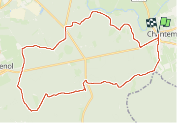

Length
11.8 km

Max alt
374 m

Uphill gradient
135 m
Km-Effort
13.6 km

Min alt
337 m

Downhill gradient
135 m
Boucle
Yes
Creation date :
2025-06-09 13:35:20.0
Updated on :
2025-07-24 17:22:47.254
3h05
Difficulty : Easy

FREE GPS app for hiking
 SityTrail
IGN / Geographical institutes
SityTrail Plus
The world is yours!
About
Trail Walking of 11.8 km to be discovered at Wallonia, Luxembourg, Étalle. This trail is proposed by francoisecarlier.
Positioning
Country:
Belgium
Region :
Wallonia
Department/Province :
Luxembourg
Municipality :
Étalle
Location:
Chantemelle
Start:(Dec)
Start:(UTM)
691398 ; 5503491 (31U) N.
Comments