


09-06-25 : Montandré

annefrance70
User
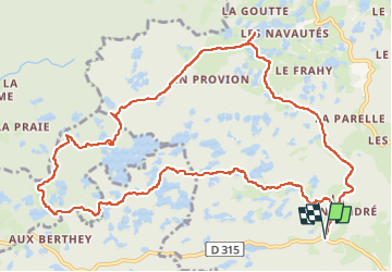

Length
13.4 km

Max alt
611 m

Uphill gradient
247 m
Km-Effort
16.7 km

Min alt
514 m

Downhill gradient
253 m
Boucle
Yes
Creation date :
2025-06-09 10:55:06.822
Updated on :
2025-06-09 16:54:45.615
3h34
Difficulty : Medium

FREE GPS app for hiking
 SityTrail
IGN / Geographical institutes
SityTrail Plus
The world is yours!
About
Trail Walking of 13.4 km to be discovered at Bourgogne-Franche-Comté, Haute-Saône, Servance-Miellin. This trail is proposed by annefrance70.
Photos


Positioning
Country:
France
Region :
Bourgogne-Franche-Comté
Department/Province :
Haute-Saône
Municipality :
Servance-Miellin
Location:
Servance
Start:(Dec)
Start:(UTM)
325172 ; 5298519 (32T) N.
Comments