


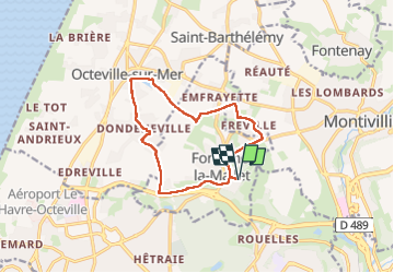
Fontaine la Mallet - circuit des vallées- ronds rouges

DDLEDANDY
User

Length
11.4 km

Max alt
87 m

Uphill gradient
118 m
Km-Effort
13 km

Min alt
28 m

Downhill gradient
118 m
Boucle
Yes
Creation date :
2025-06-10 06:41:10.268
Updated on :
2025-06-10 09:25:45.131
2h43
Difficulty : Easy

FREE GPS app for hiking
 SityTrail
IGN / Geographical institutes
SityTrail Plus
The world is yours!
About
Trail Nordic walking of 11.4 km to be discovered at Normandy, Seine-Maritime, Fontaine-la-Mallet. This trail is proposed by DDLEDANDY.
Positioning
Country:
France
Region :
Normandy
Department/Province :
Seine-Maritime
Municipality :
Fontaine-la-Mallet
Location:
Unknown
Start:(Dec)
Start:(UTM)
293907 ; 5490671 (31U) N.
Comments