


qrtignosv

vincente204
User
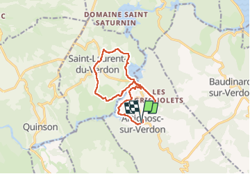

Length
13.6 km

Max alt
510 m

Uphill gradient
284 m
Km-Effort
17.3 km

Min alt
401 m

Downhill gradient
280 m
Boucle
Yes
Creation date :
2025-06-10 07:26:59.764
Updated on :
2025-06-10 13:53:41.808
6h25
Difficulty : Difficult

FREE GPS app for hiking
 SityTrail
IGN / Geographical institutes
SityTrail Plus
The world is yours!
About
Trail Walking of 13.6 km to be discovered at Provence-Alpes-Côte d'Azur, Var, Artignosc-sur-Verdon. This trail is proposed by vincente204.
Description
facile
Positioning
Country:
France
Region :
Provence-Alpes-Côte d'Azur
Department/Province :
Var
Municipality :
Artignosc-sur-Verdon
Location:
Unknown
Start:(Dec)
Start:(UTM)
265526 ; 4843042 (32T) N.
Comments