


Meung sur Loire Les Mauves 2025

Rembliere
User
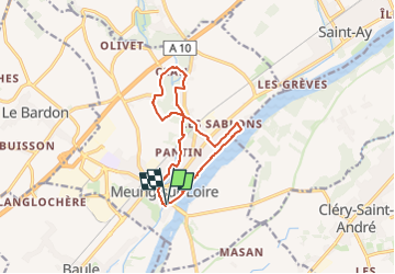

Length
11.2 km

Max alt
105 m

Uphill gradient
78 m
Km-Effort
12.3 km

Min alt
84 m

Downhill gradient
77 m
Boucle
Yes
Creation date :
2025-06-10 20:53:05.087
Updated on :
2025-06-10 20:54:00.74
2h47
Difficulty : Difficult

FREE GPS app for hiking
 SityTrail
IGN / Geographical institutes
SityTrail Plus
The world is yours!
About
Trail Walking of 11.2 km to be discovered at Centre-Loire Valley, Loiret, Meung-sur-Loire. This trail is proposed by Rembliere.
Positioning
Country:
France
Region :
Centre-Loire Valley
Department/Province :
Loiret
Municipality :
Meung-sur-Loire
Location:
Unknown
Start:(Dec)
Start:(UTM)
402541 ; 5297597 (31T) N.
Comments