


Rando facile

jpipacific
User
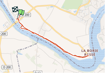

Length
4.4 km

Max alt
147 m

Uphill gradient
24 m
Km-Effort
4.7 km

Min alt
130 m

Downhill gradient
18 m
Boucle
Yes
Creation date :
2025-06-11 07:33:30.173
Updated on :
2025-06-11 09:38:59.239
1h55
Difficulty : Very easy

FREE GPS app for hiking
 SityTrail
IGN / Geographical institutes
SityTrail Plus
The world is yours!
About
Trail Walking of 4.4 km to be discovered at Occitania, Tarn, Rivières. This trail is proposed by jpipacific.
Description
Petite marche avec Sophie.
Aucune difficulté.
Champêtre le long du Tarn.
Positioning
Country:
France
Region :
Occitania
Department/Province :
Tarn
Municipality :
Rivières
Location:
Unknown
Start:(Dec)
Start:(UTM)
416743 ; 4862062 (31T) N.
Comments