


Saint marguerite - iles de Lerins

jib971
User
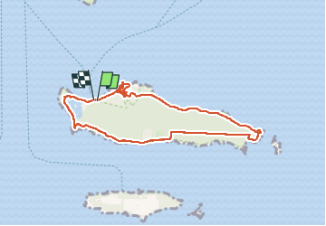

Length
8.9 km

Max alt
38 m

Uphill gradient
139 m
Km-Effort
10.7 km

Min alt
-1 m

Downhill gradient
148 m
Boucle
Yes
Creation date :
2025-06-11 09:22:37.0
Updated on :
2025-06-11 14:55:44.392

FREE GPS app for hiking
 SityTrail
IGN / Geographical institutes
SityTrail Plus
The world is yours!
About
Trail of 8.9 km to be discovered at Provence-Alpes-Côte d'Azur, Maritime Alps, Cannes. This trail is proposed by jib971.
Positioning
Country:
France
Region :
Provence-Alpes-Côte d'Azur
Department/Province :
Maritime Alps
Municipality :
Cannes
Location:
Unknown
Start:(Dec)
Start:(UTM)
341531 ; 4820628 (32T) N.
Comments