


jura 2025 lac saint Point eneo Tec

fabychat
User
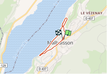

Length
2.6 km

Max alt
886 m

Uphill gradient
55 m
Km-Effort
3.3 km

Min alt
848 m

Downhill gradient
56 m
Boucle
Yes
Creation date :
2025-06-11 15:42:27.499
Updated on :
2025-06-11 16:42:28.225
59m
Difficulty : Easy

FREE GPS app for hiking
 SityTrail
IGN / Geographical institutes
SityTrail Plus
The world is yours!
About
Trail Walking of 2.6 km to be discovered at Bourgogne-Franche-Comté, Doubs, Malbuisson. This trail is proposed by fabychat.
Positioning
Country:
France
Region :
Bourgogne-Franche-Comté
Department/Province :
Doubs
Municipality :
Malbuisson
Location:
Unknown
Start:(Dec)
Start:(UTM)
294361 ; 5186425 (32T) N.
Comments