Trail Mountain bike Barjols - la source de l'eau salée par la Lauve - Photo

la source de l'eau salée par la Lauve

 bernir
bernir

User

© OpenStreetMap contributors
Length
Length
16.4 km
Max alt
Max alt
394 m
Uphill gradient
Uphill gradient
417 m
Km-Effort
Km-Effort  
22 km
Min alt
Min alt
240 m
Downhill gradient
Downhill gradient
416 m
Boucle
Boucle
Yes
Creation date :
2025-06-12 08:16:08.756
Updated on :
2025-06-28 12:43:26.51

(0 Reviews)

Mountain bike
Mountain bike
2h04
Difficulty : Medium

Scan this QR Code to open this trail in the SityTrail application

FREE GPS app for hiking

Logo SityTrail SityTrail

IGN / Geographical institutes

Download SityTrail from the App Store Download SityTrail from Google Play

Logo SityTrail SityTrail Plus

The world is yours!

Download SityTrail from the App Store Download SityTrail from Google Play Download SityTrail on Huawei AppGallery

About

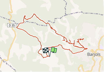
Trail Mountain bike of 16.4 km to be discovered at Provence-Alpes-Côte d'Azur, Var, Barjols. This trail is proposed by bernir.

Description

pas de sortie importante dans le petit bassin d'origine mais un bel écoulement visible en aval près de la culée nord du pont en pierre en amont du lieu de baignade disparu de "la planche"-interdit d'accès par Bagnis_il faut le dire!-

Elevation profile

Positioning

Country:
France
Region :
Provence-Alpes-Côte d'Azur
Department/Province :
Var
Municipality :
Barjols
Location:
Unknown
Start:(UTM)
740648 ; 4827001 (31T) N.


Close
My subscriptions