


La Réunion - Le Dimitile (aller-retour) par le sentier de la chapelle.

olive2b
User


5h29
Difficulty : Medium

FREE GPS app for hiking
 SityTrail
IGN / Geographical institutes
SityTrail Plus
The world is yours!
About
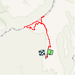
Trail Walking of 11.9 km to be discovered at Réunion, Unknown, Entre-Deux. This trail is proposed by olive2b.
Description
Balade agréable. Le départ se fait au début de la piste 4X4 au bout de la D26. Suivre le chemin qui serpente et coupe de temps à autre la piste 4X4. Profiter des points de vues (en montant) sur Saint-Pierre, La Plaine des Cafres. Et ensuite, en haut au niveau du Dimitile, les vues sur Cilaos, le Piton des Neiges, le Grand et le Petit Bénard et beaucoup d'autres sommets.
Photos
 par le sentier de la chapelle. - Photo 1")
 par le sentier de la chapelle. - Photo 2")
 par le sentier de la chapelle. - Photo 3")
 par le sentier de la chapelle. - Photo 4")
 par le sentier de la chapelle. - Photo 5")
 par le sentier de la chapelle. - Photo 6")
 par le sentier de la chapelle. - Photo 7")
 par le sentier de la chapelle. - Photo 8")
 par le sentier de la chapelle. - Photo 9")
 par le sentier de la chapelle. - Photo 10")
 par le sentier de la chapelle. - Photo 11")
 par le sentier de la chapelle. - Photo 12")
 par le sentier de la chapelle. - Photo 13")
 par le sentier de la chapelle. - Photo 14")
 par le sentier de la chapelle. - Photo 15")
 par le sentier de la chapelle. - Photo 16")
 par le sentier de la chapelle. - Photo 17")
 par le sentier de la chapelle. - Photo 18")
 par le sentier de la chapelle. - Photo 19")
 par le sentier de la chapelle. - Photo 20")
 par le sentier de la chapelle. - Photo 21")
 par le sentier de la chapelle. - Photo 22")
 par le sentier de la chapelle. - Photo 23")
 par le sentier de la chapelle. - Photo 24")
 par le sentier de la chapelle. - Photo 25")
 par le sentier de la chapelle. - Photo 26")
 par le sentier de la chapelle. - Photo 27")
 par le sentier de la chapelle. - Photo 28")
 par le sentier de la chapelle. - Photo 29")
 par le sentier de la chapelle. - Photo 30")
 par le sentier de la chapelle. - Photo 31")
 par le sentier de la chapelle. - Photo 32")
 par le sentier de la chapelle. - Photo 33")
 par le sentier de la chapelle. - Photo 34")
 par le sentier de la chapelle. - Photo 35")
 par le sentier de la chapelle. - Photo 36")
 par le sentier de la chapelle. - Photo 37")
 par le sentier de la chapelle. - Photo 38")
 par le sentier de la chapelle. - Photo 39")
 par le sentier de la chapelle. - Photo 40")
 par le sentier de la chapelle. - Photo 41")
 par le sentier de la chapelle. - Photo 42")
 par le sentier de la chapelle. - Photo 43")
 par le sentier de la chapelle. - Photo 44")
 par le sentier de la chapelle. - Photo 45")
 par le sentier de la chapelle. - Photo 46")
 par le sentier de la chapelle. - Photo 47")
 par le sentier de la chapelle. - Photo 48")
 par le sentier de la chapelle. - Photo 49")
 par le sentier de la chapelle. - Photo 50")
 par le sentier de la chapelle. - Photo 51")
 par le sentier de la chapelle. - Photo 52")
 par le sentier de la chapelle. - Photo 53")
 par le sentier de la chapelle. - Photo 54")
54 photos in total. Please click on a photo to see them all in the gallery.


Positioning
Comments
Super sympa de partager vos randonnées à la Réunion !