


Ban eux spa

castorgris
User
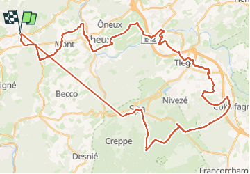

Length
51 km

Max alt
506 m

Uphill gradient
1170 m
Km-Effort
67 km

Min alt
156 m

Downhill gradient
1170 m
Boucle
Yes
Creation date :
2025-06-12 08:03:04.0
Updated on :
2025-06-12 13:53:56.444

FREE GPS app for hiking
 SityTrail
IGN / Geographical institutes
SityTrail Plus
The world is yours!
About
Trail of 51 km to be discovered at Wallonia, Liège, Sprimont. This trail is proposed by castorgris.
Positioning
Country:
Belgium
Region :
Wallonia
Department/Province :
Liège
Municipality :
Sprimont
Location:
Louveigné
Start:(Dec)
Start:(UTM)
694625 ; 5602186 (31U) N.
Comments