


Glandasse Peyrole

aldaus
User
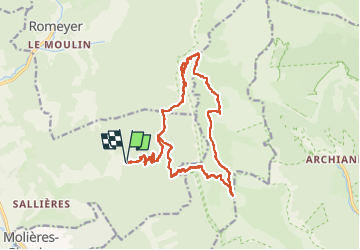

Length
22 km

Max alt
2033 m

Uphill gradient
1629 m
Km-Effort
43 km

Min alt
663 m

Downhill gradient
1631 m
Boucle
Yes
Creation date :
2025-06-12 04:08:31.169
Updated on :
2025-06-12 15:25:15.054
6h20
Difficulty : Very difficult

FREE GPS app for hiking
 SityTrail
IGN / Geographical institutes
SityTrail Plus
The world is yours!
About
Trail Walking of 22 km to be discovered at Auvergne-Rhône-Alpes, Drôme, Die. This trail is proposed by aldaus.
Positioning
Country:
France
Region :
Auvergne-Rhône-Alpes
Department/Province :
Drôme
Municipality :
Die
Location:
Unknown
Start:(Dec)
Start:(UTM)
692625 ; 4957527 (31T) N.
Comments