


Les Écrins Col d’Ornon

c.gourme
User
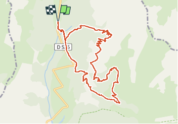

Length
12.9 km

Max alt
1872 m

Uphill gradient
948 m
Km-Effort
26 km

Min alt
1270 m

Downhill gradient
952 m
Boucle
Yes
Creation date :
2025-06-14 07:03:23.0
Updated on :
2025-06-14 14:15:03.303
6h20
Difficulty : Medium

FREE GPS app for hiking
 SityTrail
IGN / Geographical institutes
SityTrail Plus
The world is yours!
About
Trail Walking of 12.9 km to be discovered at Auvergne-Rhône-Alpes, Isère, Chantepérier. This trail is proposed by c.gourme.
Positioning
Country:
France
Region :
Auvergne-Rhône-Alpes
Department/Province :
Isère
Municipality :
Chantepérier
Location:
Chantelouve
Start:(Dec)
Start:(UTM)
733849 ; 4988038 (31T) N.
Comments