


VTT leyrieu

almathieu
User

Length
30 km

Max alt
436 m

Uphill gradient
408 m
Km-Effort
36 km

Min alt
202 m

Downhill gradient
443 m
Boucle
No
Creation date :
2025-06-14 18:46:07.792
Updated on :
2025-06-14 18:46:09.325
2h29
Difficulty : Difficult

FREE GPS app for hiking
 SityTrail
IGN / Geographical institutes
SityTrail Plus
The world is yours!
About
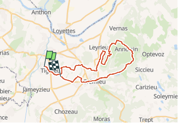
Trail Mountain bike of 30 km to be discovered at Auvergne-Rhône-Alpes, Isère, Tignieu-Jameyzieu. This trail is proposed by almathieu.
Positioning
Country:
France
Region :
Auvergne-Rhône-Alpes
Department/Province :
Isère
Municipality :
Tignieu-Jameyzieu
Location:
Unknown
Start:(Dec)
Start:(UTM)
669467 ; 5067362 (31T) N.
Comments