


saillant de Saint Mihiel 17 kms

sandra54570
User
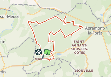

Length
17.6 km

Max alt
379 m

Uphill gradient
375 m
Km-Effort
23 km

Min alt
243 m

Downhill gradient
375 m
Boucle
Yes
Creation date :
2025-06-16 10:35:22.639
Updated on :
2025-06-16 10:35:24.408
5h08
Difficulty : Very difficult

FREE GPS app for hiking
 SityTrail
IGN / Geographical institutes
SityTrail Plus
The world is yours!
About
Trail Walking of 17.6 km to be discovered at Grand Est, Meuse, Apremont-la-Forêt. This trail is proposed by sandra54570.
Positioning
Country:
France
Region :
Grand Est
Department/Province :
Meuse
Municipality :
Apremont-la-Forêt
Location:
Marbotte
Start:(Dec)
Start:(UTM)
689428 ; 5412265 (31U) N.
Comments