


Lac d’Ayés réalisé

611686735
User
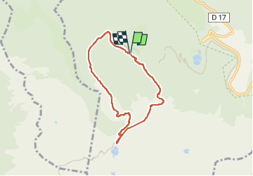

Length
7 km

Max alt
1729 m

Uphill gradient
385 m
Km-Effort
12.2 km

Min alt
1401 m

Downhill gradient
387 m
Boucle
Yes
Creation date :
2025-06-16 07:41:58.0
Updated on :
2025-06-16 12:54:49.429
5h09
Difficulty : Easy

FREE GPS app for hiking
 SityTrail
IGN / Geographical institutes
SityTrail Plus
The world is yours!
About
Trail Walking of 7 km to be discovered at Occitania, Ariège, Bethmale. This trail is proposed by 611686735.
Positioning
Country:
France
Region :
Occitania
Department/Province :
Ariège
Municipality :
Bethmale
Location:
Unknown
Start:(Dec)
Start:(UTM)
342143 ; 4747243 (31T) N.
Comments