


T-OG-Rando-1

CSR-94
User

Length
21 km

Max alt
805 m

Uphill gradient
646 m
Km-Effort
30 km

Min alt
217 m

Downhill gradient
728 m
Boucle
No
Creation date :
2025-06-16 07:03:27.356
Updated on :
2025-06-22 16:37:13.55
7h38
Difficulty : Very difficult

FREE GPS app for hiking
 SityTrail
IGN / Geographical institutes
SityTrail Plus
The world is yours!
About
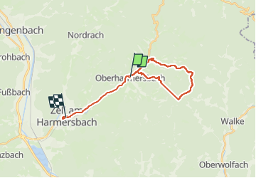
Trail Walking of 21 km to be discovered at Baden-Württemberg, Ortenaukreis, Oberharmersbach. This trail is proposed by CSR-94.
Positioning
Country:
Germany
Region :
Baden-Württemberg
Department/Province :
Ortenaukreis
Municipality :
Oberharmersbach
Location:
Unknown
Start:(Dec)
Start:(UTM)
435344 ; 5358179 (32U) N.
Comments