


Carry

Roger Philippe Wallez
User GUIDE

Length
12.1 km

Max alt
113 m

Uphill gradient
397 m
Km-Effort
17.4 km

Min alt
3 m

Downhill gradient
399 m
Boucle
Yes
Creation date :
2025-06-15 08:38:46.0
Updated on :
2025-06-17 17:11:41.128
6h30
Difficulty : Difficult

FREE GPS app for hiking
 SityTrail
IGN / Geographical institutes
SityTrail Plus
The world is yours!
About
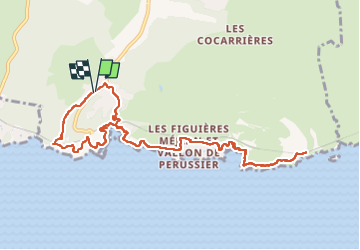
Trail Walking of 12.1 km to be discovered at Provence-Alpes-Côte d'Azur, Bouches-du-Rhône, Ensuès-la-Redonne. This trail is proposed by Roger Philippe Wallez.
Photos


Positioning
Country:
France
Region :
Provence-Alpes-Côte d'Azur
Department/Province :
Bouches-du-Rhône
Municipality :
Ensuès-la-Redonne
Location:
Unknown
Start:(Dec)
Start:(UTM)
677935 ; 4800709 (31T) N.
Comments