


vel m'ont 18 06

micheleuvrard
User

Length
23 km

Max alt
398 m

Uphill gradient
418 m
Km-Effort
28 km

Min alt
187 m

Downhill gradient
418 m
Boucle
Yes
Creation date :
2025-06-18 07:27:06.374
Updated on :
2025-06-18 09:29:06.552
2h01
Difficulty : Medium

FREE GPS app for hiking
 SityTrail
IGN / Geographical institutes
SityTrail Plus
The world is yours!
About
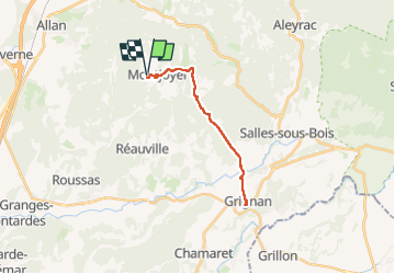
Trail Road bike of 23 km to be discovered at Auvergne-Rhône-Alpes, Drôme, Montjoyer. This trail is proposed by micheleuvrard.
Positioning
Country:
France
Region :
Auvergne-Rhône-Alpes
Department/Province :
Drôme
Municipality :
Montjoyer
Location:
Unknown
Start:(Dec)
Start:(UTM)
646868 ; 4926508 (31T) N.
Comments