


erreur
© OpenStreetMap contributors


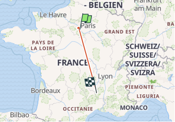
31h20
Difficulty : Very difficult


Length
527 km
Max alt
1345 m
Uphill gradient
13714 m
Km-Effort
705 km
Min alt
26 m
Downhill gradient
12476 m
Boucle
No
Creation date :
2025-06-11 15:18:45.765
Updated on :
2025-06-18 09:40:31.546
31h20
Difficulty : Very difficult
FREE GPS app for hiking
 SityTrail
IGN / Geographical institutes
SityTrail Plus
The world is yours!
About
Trail Walking of 527 km to be discovered at Ile-de-France, Seine-et-Marne, Savigny-le-Temple. This trail is proposed by Félix RODRIGUEZ VAZQUEZ.
Positioning
Country:
France
Region :
Ile-de-France
Department/Province :
Seine-et-Marne
Municipality :
Savigny-le-Temple
Location:
Unknown
Start:(Dec)
Start:(UTM)
468003 ; 5382503 (31U) N.
Comments