


T-DD-RANDO 2

RANDOH
User

Length
13.8 km

Max alt
553 m

Uphill gradient
643 m
Km-Effort
22 km

Min alt
293 m

Downhill gradient
644 m
Boucle
Yes
Creation date :
2025-06-18 07:34:37.672
Updated on :
2025-06-18 13:58:32.896
6h21
Difficulty : Difficult

FREE GPS app for hiking
 SityTrail
IGN / Geographical institutes
SityTrail Plus
The world is yours!
About
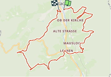
Trail Walking of 13.8 km to be discovered at Baden-Württemberg, Ortenaukreis, Gutach (Schwarzwaldbahn). This trail is proposed by RANDOH.
Positioning
Country:
Germany
Region :
Baden-Württemberg
Department/Province :
Ortenaukreis
Municipality :
Gutach (Schwarzwaldbahn)
Location:
Unknown
Start:(Dec)
Start:(UTM)
441549 ; 5344254 (32U) N.
Comments