


Vincent

francisdean
User
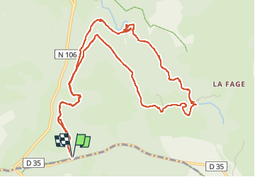

Length
14.3 km

Max alt
1168 m

Uphill gradient
379 m
Km-Effort
19.3 km

Min alt
946 m

Downhill gradient
380 m
Boucle
Yes
Creation date :
2025-06-18 07:17:41.429
Updated on :
2025-06-18 14:21:18.965
7h02
Difficulty : Medium

FREE GPS app for hiking
 SityTrail
IGN / Geographical institutes
SityTrail Plus
The world is yours!
About
Trail Walking of 14.3 km to be discovered at Occitania, Lozère, Saint-Étienne-du-Valdonnez. This trail is proposed by francisdean.
Positioning
Country:
France
Region :
Occitania
Department/Province :
Lozère
Municipality :
Saint-Étienne-du-Valdonnez
Location:
Unknown
Start:(Dec)
Start:(UTM)
544400 ; 4918775 (31T) N.
Comments