


Etape 5 GR70 les hauts-Cheylards - la Bastide de PuyLaurent

Lobin
User
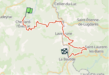

Length
29 km

Max alt
1249 m

Uphill gradient
743 m
Km-Effort
39 km

Min alt
969 m

Downhill gradient
888 m
Boucle
No
Creation date :
2025-06-18 05:48:07.0
Updated on :
2025-06-18 15:48:08.504
8h45
Difficulty : Difficult

FREE GPS app for hiking
 SityTrail
IGN / Geographical institutes
SityTrail Plus
The world is yours!
About
Trail Walking of 29 km to be discovered at Occitania, Lozère, Cheylard-l'Évêque. This trail is proposed by Lobin.
Photos

Positioning
Country:
France
Region :
Occitania
Department/Province :
Lozère
Municipality :
Cheylard-l'Évêque
Location:
Unknown
Start:(Dec)
Start:(UTM)
564055 ; 4945295 (31T) N.
Comments