


la Routo Seyne le Vernet

taguette
User
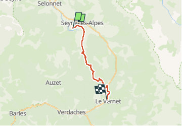

Length
15.6 km

Max alt
1450 m

Uphill gradient
417 m
Km-Effort
21 km

Min alt
1125 m

Downhill gradient
345 m
Boucle
No
Creation date :
2025-06-19 05:15:55.792
Updated on :
2025-06-19 09:27:08.647
4h10
Difficulty : Very difficult

FREE GPS app for hiking
 SityTrail
IGN / Geographical institutes
SityTrail Plus
The world is yours!
About
Trail Walking of 15.6 km to be discovered at Provence-Alpes-Côte d'Azur, Alpes-de-Haute-Provence, Seyne. This trail is proposed by taguette.
Positioning
Country:
France
Region :
Provence-Alpes-Côte d'Azur
Department/Province :
Alpes-de-Haute-Provence
Municipality :
Seyne
Location:
Unknown
Start:(Dec)
Start:(UTM)
288292 ; 4913790 (32T) N.
Comments