


le Thoronet

HENRY83
User

Length
64 km

Max alt
245 m

Uphill gradient
777 m
Km-Effort
75 km

Min alt
48 m

Downhill gradient
777 m
Boucle
Yes
Creation date :
2025-06-19 05:53:38.312
Updated on :
2025-06-19 09:54:50.229
3h50
Difficulty : Medium

FREE GPS app for hiking
 SityTrail
IGN / Geographical institutes
SityTrail Plus
The world is yours!
About
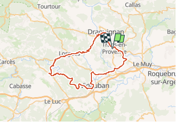
Trail Road bike of 64 km to be discovered at Provence-Alpes-Côte d'Azur, Var, Trans-en-Provence. This trail is proposed by HENRY83.
Positioning
Country:
France
Region :
Provence-Alpes-Côte d'Azur
Department/Province :
Var
Municipality :
Trans-en-Provence
Location:
Unknown
Start:(Dec)
Start:(UTM)
296402 ; 4819631 (32T) N.
Comments