


rando sault brenaz

cleu
User
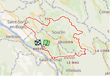

Length
22 km

Max alt
859 m

Uphill gradient
910 m
Km-Effort
35 km

Min alt
208 m

Downhill gradient
913 m
Boucle
Yes
Creation date :
2025-06-19 06:44:43.766
Updated on :
2025-06-19 19:15:24.708
12h20
Difficulty : Very difficult

FREE GPS app for hiking
 SityTrail
IGN / Geographical institutes
SityTrail Plus
The world is yours!
About
Trail Walking of 22 km to be discovered at Auvergne-Rhône-Alpes, Ain, Sault-Brénaz. This trail is proposed by cleu.
Positioning
Country:
France
Region :
Auvergne-Rhône-Alpes
Department/Province :
Ain
Municipality :
Sault-Brénaz
Location:
Unknown
Start:(Dec)
Start:(UTM)
686306 ; 5081600 (31T) N.
Comments