


lacs laramon serpent +4.2025.06.18

trusgnachjf
User
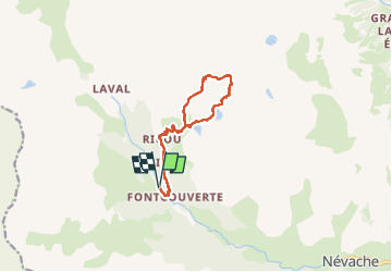

Length
12.4 km

Max alt
2687 m

Uphill gradient
829 m
Km-Effort
23 km

Min alt
1862 m

Downhill gradient
828 m
Boucle
Yes
Creation date :
2025-06-18 09:14:49.04
Updated on :
2025-06-19 20:04:46.509
8h02
Difficulty : Very difficult

FREE GPS app for hiking
 SityTrail
IGN / Geographical institutes
SityTrail Plus
The world is yours!
About
Trail Walking of 12.4 km to be discovered at Provence-Alpes-Côte d'Azur, Hautes-Alpes, Névache. This trail is proposed by trusgnachjf.
Positioning
Country:
France
Region :
Provence-Alpes-Côte d'Azur
Department/Province :
Hautes-Alpes
Municipality :
Névache
Location:
Unknown
Start:(Dec)
Start:(UTM)
306552 ; 4989830 (32T) N.
Comments