


St Sulpice via porte de Bourdeaux

reflexe
User
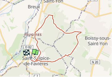

Length
7.5 km

Max alt
158 m

Uphill gradient
149 m
Km-Effort
9.5 km

Min alt
86 m

Downhill gradient
149 m
Boucle
Yes
Creation date :
2025-06-20 12:36:44.911
Updated on :
2025-06-20 12:41:17.115
2h08
Difficulty : Easy

FREE GPS app for hiking
 SityTrail
IGN / Geographical institutes
SityTrail Plus
The world is yours!
About
Trail On foot of 7.5 km to be discovered at Ile-de-France, Essonne, Saint-Sulpice-de-Favières. This trail is proposed by reflexe.
Description
boucle
Positioning
Country:
France
Region :
Ile-de-France
Department/Province :
Essonne
Municipality :
Saint-Sulpice-de-Favières
Location:
Unknown
Start:(Dec)
Start:(UTM)
439147 ; 5376864 (31U) N.
Comments