


Thynes - Dinant

BrigitteBertrand
User
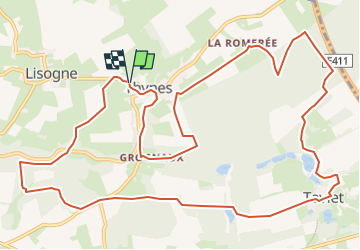

Length
14.3 km

Max alt
304 m

Uphill gradient
301 m
Km-Effort
18.3 km

Min alt
186 m

Downhill gradient
305 m
Boucle
Yes
Creation date :
2025-06-20 13:32:05.215
Updated on :
2025-06-20 13:33:13.321
4h09
Difficulty : Easy

FREE GPS app for hiking
 SityTrail
IGN / Geographical institutes
SityTrail Plus
The world is yours!
About
Trail On foot of 14.3 km to be discovered at Wallonia, Namur, Dinant. This trail is proposed by BrigitteBertrand.
Description
Vers Taviet et ses étangs
Positioning
Country:
Belgium
Region :
Wallonia
Department/Province :
Namur
Municipality :
Dinant
Location:
Unknown
Start:(Dec)
Start:(UTM)
641433 ; 5571678 (31U) N.
Comments