


Col Turini - Sospel

newman
User
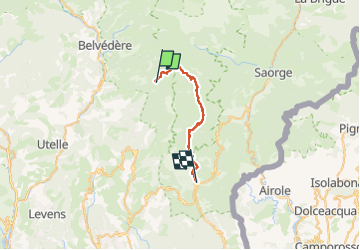

Length
23 km

Max alt
1931 m

Uphill gradient
619 m
Km-Effort
35 km

Min alt
348 m

Downhill gradient
1877 m
Boucle
No
Creation date :
2025-06-21 12:25:14.34
Updated on :
2025-06-21 12:25:47.085
8h00
Difficulty : Very difficult

FREE GPS app for hiking
 SityTrail
IGN / Geographical institutes
SityTrail Plus
The world is yours!
About
Trail Walking of 23 km to be discovered at Provence-Alpes-Côte d'Azur, Maritime Alps, Moulinet. This trail is proposed by newman.
Positioning
Country:
France
Region :
Provence-Alpes-Côte d'Azur
Department/Province :
Maritime Alps
Municipality :
Moulinet
Location:
Unknown
Start:(Dec)
Start:(UTM)
371002 ; 4870669 (32T) N.
Comments