


croix fry - beauregard

jcguew
User
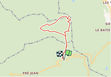

Length
6.6 km

Max alt
1638 m

Uphill gradient
257 m
Km-Effort
10.1 km

Min alt
1462 m

Downhill gradient
260 m
Boucle
Yes
Creation date :
2025-06-21 15:36:07.961
Updated on :
2025-06-21 15:36:10.4
2h17
Difficulty : Medium

FREE GPS app for hiking
 SityTrail
IGN / Geographical institutes
SityTrail Plus
The world is yours!
About
Trail Walking of 6.6 km to be discovered at Auvergne-Rhône-Alpes, Upper Savoy, Manigod. This trail is proposed by jcguew.
Positioning
Country:
France
Region :
Auvergne-Rhône-Alpes
Department/Province :
Upper Savoy
Municipality :
Manigod
Location:
Unknown
Start:(Dec)
Start:(UTM)
298517 ; 5083644 (32T) N.
Comments