


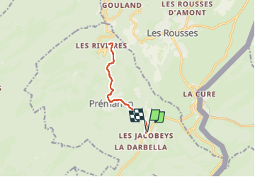
Prémanon

sameja
User

Length
10.1 km

Max alt
1171 m

Uphill gradient
262 m
Km-Effort
13.6 km

Min alt
949 m

Downhill gradient
260 m
Boucle
Yes
Creation date :
2025-06-21 17:05:16.0
Updated on :
2025-06-21 18:30:42.643
1h20
Difficulty : Medium

FREE GPS app for hiking
 SityTrail
IGN / Geographical institutes
SityTrail Plus
The world is yours!
About
Trail Trail of 10.1 km to be discovered at Bourgogne-Franche-Comté, Jura, Prémanon. This trail is proposed by sameja.
Description
Cnsnmm
Photos


Positioning
Country:
France
Region :
Bourgogne-Franche-Comté
Department/Province :
Jura
Municipality :
Prémanon
Location:
Unknown
Start:(Dec)
Start:(UTM)
273317 ; 5148532 (32T) N.
Comments