


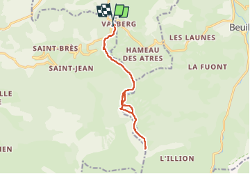
Cime de Raton
© OpenStreetMap contributors


5h41
Difficulty : Very difficult


Length
14.1 km
Max alt
2058 m
Uphill gradient
526 m
Km-Effort
21 km
Min alt
1676 m
Downhill gradient
527 m
Boucle
Yes
Creation date :
2025-06-22 06:41:52.0
Updated on :
2025-06-22 12:24:42.478
5h41
Difficulty : Very difficult
FREE GPS app for hiking
 SityTrail
IGN / Geographical institutes
SityTrail Plus
The world is yours!
About
Trail Walking of 14.1 km to be discovered at Provence-Alpes-Côte d'Azur, Maritime Alps, Guillaumes. This trail is proposed by 000549.742464c1b03a4f089954791b77f25409.1417.
Positioning
Country:
France
Region :
Provence-Alpes-Côte d'Azur
Department/Province :
Maritime Alps
Municipality :
Guillaumes
Location:
Unknown
Start:(Dec)
Start:(UTM)
334057 ; 4884484 (32T) N.
Comments