


Ici

Airelle
User
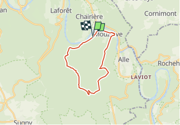

Length
10.1 km

Max alt
375 m

Uphill gradient
279 m
Km-Effort
13.8 km

Min alt
189 m

Downhill gradient
287 m
Boucle
Yes
Creation date :
2025-06-23 05:41:44.0
Updated on :
2025-06-23 05:41:45.031

FREE GPS app for hiking
 SityTrail
IGN / Geographical institutes
SityTrail Plus
The world is yours!
About
Trail of 10.1 km to be discovered at Wallonia, Namur, Vresse-sur-Semois. This trail is proposed by Airelle.
Positioning
Country:
Belgium
Region :
Wallonia
Department/Province :
Namur
Municipality :
Vresse-sur-Semois
Location:
Unknown
Start:(Dec)
Start:(UTM)
640281 ; 5523969 (31U) N.
Comments