


Avioth

francoisecarlier
User
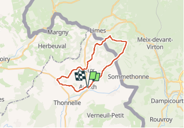

Length
20 km

Max alt
336 m

Uphill gradient
384 m
Km-Effort
25 km

Min alt
201 m

Downhill gradient
388 m
Boucle
Yes
Creation date :
2025-06-22 08:19:50.0
Updated on :
2025-07-24 17:21:57.627
5h45
Difficulty : Easy

FREE GPS app for hiking
 SityTrail
IGN / Geographical institutes
SityTrail Plus
The world is yours!
About
Trail Walking of 20 km to be discovered at Grand Est, Meuse, Avioth. This trail is proposed by francoisecarlier.
Description
Parcours agréable et facile malgré la distance. Attention à ne pas faire par temps très chaud; la deuxième partie n'offrant quasiment pas d'ombre.
Positioning
Country:
France
Region :
Grand Est
Department/Province :
Meuse
Municipality :
Avioth
Location:
Unknown
Start:(Dec)
Start:(UTM)
672894 ; 5493210 (31U) N.
Comments