


la Routo l'Averq/ camping River

taguette
User
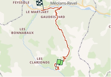

Length
13.2 km

Max alt
2281 m

Uphill gradient
713 m
Km-Effort
25 km

Min alt
968 m

Downhill gradient
1332 m
Boucle
No
Creation date :
2025-06-23 05:38:07.412
Updated on :
2025-06-23 11:54:59.156
6h15
Difficulty : Very difficult

FREE GPS app for hiking
 SityTrail
IGN / Geographical institutes
SityTrail Plus
The world is yours!
About
Trail Walking of 13.2 km to be discovered at Provence-Alpes-Côte d'Azur, Alpes-de-Haute-Provence, Méolans-Revel. This trail is proposed by taguette.
Positioning
Country:
France
Region :
Provence-Alpes-Côte d'Azur
Department/Province :
Alpes-de-Haute-Provence
Municipality :
Méolans-Revel
Location:
Unknown
Start:(Dec)
Start:(UTM)
300896 ; 4913692 (32T) N.
Comments