


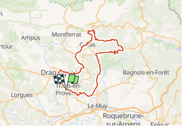
callas.bargemon.clavier.la motte.

HENRY83
User

Length
67 km

Max alt
482 m

Uphill gradient
1124 m
Km-Effort
82 km

Min alt
57 m

Downhill gradient
1125 m
Boucle
Yes
Creation date :
2025-06-23 05:06:10.139
Updated on :
2025-06-23 12:30:01.547
3h00
Difficulty : Medium

FREE GPS app for hiking
 SityTrail
IGN / Geographical institutes
SityTrail Plus
The world is yours!
About
Trail Road bike of 67 km to be discovered at Provence-Alpes-Côte d'Azur, Var, Trans-en-Provence. This trail is proposed by HENRY83.
Description
sortie velo
Positioning
Country:
France
Region :
Provence-Alpes-Côte d'Azur
Department/Province :
Var
Municipality :
Trans-en-Provence
Location:
Unknown
Start:(Dec)
Start:(UTM)
296418 ; 4819670 (32T) N.
Comments