


20250624gavres2

michelelfn
User
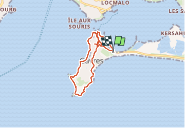

Length
6.8 km

Max alt
9 m

Uphill gradient
34 m
Km-Effort
7.2 km

Min alt
-1 m

Downhill gradient
31 m
Boucle
Yes
Creation date :
2025-06-24 09:09:31.954
Updated on :
2025-06-24 11:21:24.073
2h11
Difficulty : Medium

FREE GPS app for hiking
 SityTrail
IGN / Geographical institutes
SityTrail Plus
The world is yours!
About
Trail Walking of 6.8 km to be discovered at Brittany, Morbihan, Gâvres. This trail is proposed by michelelfn.
Positioning
Country:
France
Region :
Brittany
Department/Province :
Morbihan
Municipality :
Gâvres
Location:
Unknown
Start:(Dec)
Start:(UTM)
473980 ; 5282557 (30T) N.
Comments