


La Routo Barcelonnette le Martinet

taguette
User
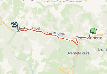

Length
17.9 km

Max alt
1181 m

Uphill gradient
309 m
Km-Effort
23 km

Min alt
964 m

Downhill gradient
479 m
Boucle
No
Creation date :
2025-06-24 07:04:00.229
Updated on :
2025-06-24 13:06:23.869
6h01
Difficulty : Very difficult

FREE GPS app for hiking
 SityTrail
IGN / Geographical institutes
SityTrail Plus
The world is yours!
About
Trail Walking of 17.9 km to be discovered at Provence-Alpes-Côte d'Azur, Alpes-de-Haute-Provence, Barcelonnette. This trail is proposed by taguette.
Positioning
Country:
France
Region :
Provence-Alpes-Côte d'Azur
Department/Province :
Alpes-de-Haute-Provence
Municipality :
Barcelonnette
Location:
Unknown
Start:(Dec)
Start:(UTM)
312947 ; 4917498 (32T) N.
Comments