


SUPER BESSE UY DE SANCY. PUY PARIOU O

RobinMicheline
User GUIDE
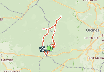

Length
12.7 km

Max alt
1453 m

Uphill gradient
564 m
Km-Effort
20 km

Min alt
1061 m

Downhill gradient
572 m
Boucle
Yes
Creation date :
2025-06-24 07:48:41.103
Updated on :
2025-06-24 14:03:52.279
4h00
Difficulty : Very difficult

FREE GPS app for hiking
 SityTrail
IGN / Geographical institutes
SityTrail Plus
The world is yours!
About
Trail Walking of 12.7 km to be discovered at Auvergne-Rhône-Alpes, Puy-de-Dôme, Ceyssat. This trail is proposed by RobinMicheline.
Photos


Positioning
Country:
France
Region :
Auvergne-Rhône-Alpes
Department/Province :
Puy-de-Dôme
Municipality :
Ceyssat
Location:
Unknown
Start:(Dec)
Start:(UTM)
496545 ; 5067882 (31T) N.
Comments