


Le col de l’Aup depuis les hauts Giron

FouargePatrick
User
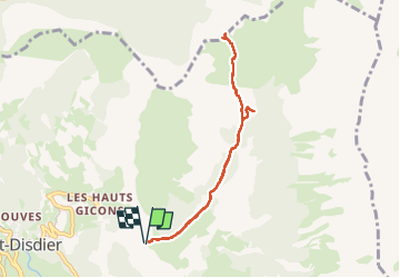

Length
7.5 km

Max alt
1691 m

Uphill gradient
348 m
Km-Effort
12.1 km

Min alt
1343 m

Downhill gradient
344 m
Boucle
Yes
Creation date :
2025-06-24 08:51:50.0
Updated on :
2025-07-01 10:19:27.715
4h07
Difficulty : Difficult

FREE GPS app for hiking
 SityTrail
IGN / Geographical institutes
SityTrail Plus
The world is yours!
About
Trail Walking of 7.5 km to be discovered at Provence-Alpes-Côte d'Azur, Hautes-Alpes, Le Dévoluy. This trail is proposed by FouargePatrick.
Photos

Positioning
Country:
France
Region :
Provence-Alpes-Côte d'Azur
Department/Province :
Hautes-Alpes
Municipality :
Le Dévoluy
Location:
Saint-Disdier
Start:(Dec)
Start:(UTM)
730867 ; 4957654 (31T) N.
Comments