


Mijanès pic de tarbesou 922m 18kms

Danielba
User GUIDE
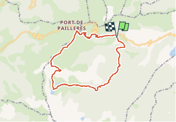

Length
17.5 km

Max alt
2351 m

Uphill gradient
942 m
Km-Effort
30 km

Min alt
1528 m

Downhill gradient
937 m
Boucle
Yes
Creation date :
2025-06-24 06:59:37.626
Updated on :
2025-06-24 15:10:05.531
7h57
Difficulty : Medium

FREE GPS app for hiking
 SityTrail
IGN / Geographical institutes
SityTrail Plus
The world is yours!
About
Trail Walking of 17.5 km to be discovered at Occitania, Ariège, Mijanès. This trail is proposed by Danielba .
Photos


Positioning
Country:
France
Region :
Occitania
Department/Province :
Ariège
Municipality :
Mijanès
Location:
Unknown
Start:(Dec)
Start:(UTM)
419513 ; 4731067 (31T) N.
Comments