


Mau 25 o6

Padre38240
User
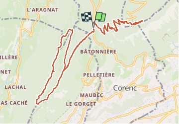

Length
15.2 km

Max alt
1324 m

Uphill gradient
972 m
Km-Effort
28 km

Min alt
767 m

Downhill gradient
982 m
Boucle
Yes
Creation date :
2025-06-25 05:24:19.0
Updated on :
2025-06-25 11:16:19.043
4h33
Difficulty : Medium

FREE GPS app for hiking
 SityTrail
IGN / Geographical institutes
SityTrail Plus
The world is yours!
About
Trail Walking of 15.2 km to be discovered at Auvergne-Rhône-Alpes, Isère, Corenc. This trail is proposed by Padre38240.
Positioning
Country:
France
Region :
Auvergne-Rhône-Alpes
Department/Province :
Isère
Municipality :
Corenc
Location:
Unknown
Start:(Dec)
Start:(UTM)
715935 ; 5012662 (31T) N.
Comments