


chadenas. embrun

COLLOMBAlain
User
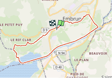

Length
9.8 km

Max alt
888 m

Uphill gradient
209 m
Km-Effort
12.6 km

Min alt
776 m

Downhill gradient
209 m
Boucle
Yes
Creation date :
2025-06-25 17:48:41.531
Updated on :
2025-06-25 19:56:16.274
2h06
Difficulty : Difficult

FREE GPS app for hiking
 SityTrail
IGN / Geographical institutes
SityTrail Plus
The world is yours!
About
Trail Walking of 9.8 km to be discovered at Provence-Alpes-Côte d'Azur, Hautes-Alpes, Embrun. This trail is proposed by COLLOMBAlain.
Positioning
Country:
France
Region :
Provence-Alpes-Côte d'Azur
Department/Province :
Hautes-Alpes
Municipality :
Embrun
Location:
Unknown
Start:(Dec)
Start:(UTM)
300456 ; 4937105 (32T) N.
Comments