


Ile Verte sud

Pierrannick
User

Length
63 km

Max alt
181 m

Uphill gradient
568 m
Km-Effort
70 km

Min alt
54 m

Downhill gradient
568 m
Boucle
Yes
Creation date :
2025-06-26 07:26:23.045
Updated on :
2025-06-26 07:26:44.761
0m
Difficulty : Very easy

FREE GPS app for hiking
 SityTrail
IGN / Geographical institutes
SityTrail Plus
The world is yours!
About
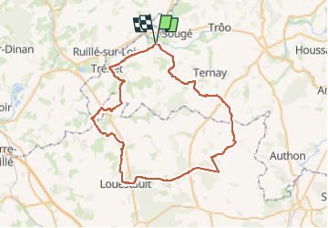
Trail Cycle of 63 km to be discovered at Centre-Loire Valley, Loir-et-Cher, Vallée-de-Ronsard. This trail is proposed by Pierrannick.
Positioning
Country:
France
Region :
Centre-Loire Valley
Department/Province :
Loir-et-Cher
Municipality :
Vallée-de-Ronsard
Location:
Couture-sur-Loir
Start:(Dec)
Start:(UTM)
327330 ; 5291993 (31T) N.
Comments