


Puy st Vincent j6 Les cascades

phidge
User
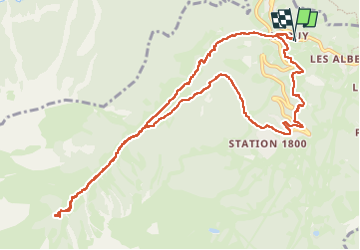

Length
12.9 km

Max alt
2057 m

Uphill gradient
679 m
Km-Effort
22 km

Min alt
1391 m

Downhill gradient
680 m
Boucle
Yes
Creation date :
2025-06-27 05:21:26.959
Updated on :
2025-06-28 12:58:26.791
7h25
Difficulty : Very difficult

FREE GPS app for hiking
 SityTrail
IGN / Geographical institutes
SityTrail Plus
The world is yours!
About
Trail Walking of 12.9 km to be discovered at Provence-Alpes-Côte d'Azur, Hautes-Alpes, Puy-Saint-Vincent. This trail is proposed by phidge.
Positioning
Country:
France
Region :
Provence-Alpes-Côte d'Azur
Department/Province :
Hautes-Alpes
Municipality :
Puy-Saint-Vincent
Location:
Unknown
Start:(Dec)
Start:(UTM)
301275 ; 4967185 (32T) N.
Comments