


Trace G3 Beaucens Picalongue Guy 270625

mitch1952
User
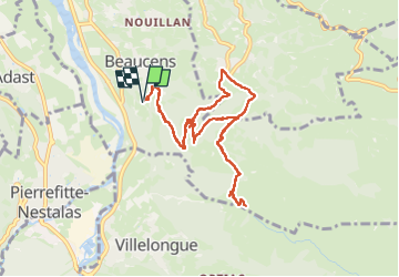

Length
10.8 km

Max alt
1120 m

Uphill gradient
650 m
Km-Effort
19.5 km

Min alt
522 m

Downhill gradient
650 m
Boucle
Yes
Creation date :
2025-06-27 07:12:09.0
Updated on :
2025-06-27 12:52:48.607

FREE GPS app for hiking
 SityTrail
IGN / Geographical institutes
SityTrail Plus
The world is yours!
About
Trail of 10.8 km to be discovered at Occitania, Hautespyrenees, Beaucens. This trail is proposed by mitch1952.
Positioning
Country:
France
Region :
Occitania
Department/Province :
Hautespyrenees
Municipality :
Beaucens
Location:
Unknown
Start:(Dec)
Start:(UTM)
739812 ; 4761765 (30T) N.
Comments