


Stevenson 3

Chabard
User

Length
26 km

Max alt
1264 m

Uphill gradient
465 m
Km-Effort
32 km

Min alt
985 m

Downhill gradient
528 m
Boucle
No
Creation date :
2025-06-28 06:19:36.0
Updated on :
2025-06-28 14:47:43.112
8h26
Difficulty : Medium

FREE GPS app for hiking
 SityTrail
IGN / Geographical institutes
SityTrail Plus
The world is yours!
About
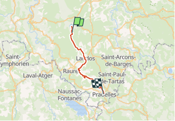
Trail Walking of 26 km to be discovered at Auvergne-Rhône-Alpes, Haute-Loire, Le Bouchet-Saint-Nicolas. This trail is proposed by Chabard.
Description
Le Bouchet Saint-Nicolas - Pradelles
Positioning
Country:
France
Region :
Auvergne-Rhône-Alpes
Department/Province :
Haute-Loire
Municipality :
Le Bouchet-Saint-Nicolas
Location:
Unknown
Start:(Dec)
Start:(UTM)
562630 ; 4971488 (31T) N.
Comments