


Monténégro J2

tyax93
User
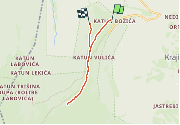

Length
5.7 km

Max alt
1941 m

Uphill gradient
180 m
Km-Effort
8.1 km

Min alt
1732 m

Downhill gradient
197 m
Boucle
No
Creation date :
2024-09-18 11:53:14.254
Updated on :
2025-06-28 15:30:03.906
6h07
Difficulty : Medium

FREE GPS app for hiking
 SityTrail
IGN / Geographical institutes
SityTrail Plus
The world is yours!
About
Trail Walking of 5.7 km to be discovered at Unknown, Andrijevica Municipality. This trail is proposed by tyax93.
Positioning
Country:
Montenegro
Region :
Unknown
Department/Province :
Andrijevica Municipality
Municipality :
Unknown
Location:
Unknown
Start:(Dec)
Start:(UTM)
392310 ; 4730128 (34T) N.
Comments