


20260629 Perche Nico Audray

Jeanclaudebic
User
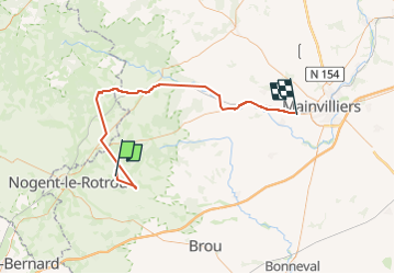

Length
70 km

Max alt
289 m

Uphill gradient
854 m
Km-Effort
82 km

Min alt
145 m

Downhill gradient
964 m
Boucle
No
Creation date :
2025-06-29 08:55:48.671
Updated on :
2025-06-29 14:06:18.516
5h08
Difficulty : Very difficult

FREE GPS app for hiking
 SityTrail
IGN / Geographical institutes
SityTrail Plus
The world is yours!
About
Trail Walking of 70 km to be discovered at Centre-Loire Valley, Eure-et-Loir, Arcisses. This trail is proposed by Jeanclaudebic.
Positioning
Country:
France
Region :
Centre-Loire Valley
Department/Province :
Eure-et-Loir
Municipality :
Arcisses
Location:
Coudreceau
Start:(Dec)
Start:(UTM)
347542 ; 5355316 (31U) N.
Comments